
The trail known as “Sendero del Agua” – “the Water Trail” in English – is the result of efforts on behalf of the town of Los Realejos, during several decades, of bit by bit renovation of the old trails that were used by locals and fishermen to gain access to the coast.
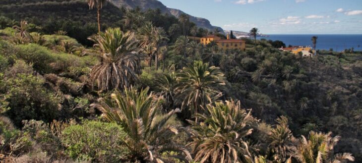
Now, most of the expanse of the nature reserve of the Rambla de Castro with its different enclaves, can be visited on foot, and the beauty of the municipality of Los Realejos’ coast with its sand and pebble beaches, bays and natural pools can be appreciated. All this
within the protection of the reserve that was established in 1987, that received its current denomination in 1994, and has a surface area of 45.9 hectares.
This trail offers visitors the opportunity to take an interest in the area’s natural wealth, its fauna and flora and its need for preservation.
The trail leads into one of the most beautiful areas of the island, where nature, history, the landscape and legends merge in a journey sprinkled with beauty and with the always present murmuring of water.
The famous palm grove, the Castro manor, San Fernando’s Fort and the pump station of la Gordejuela are essential waypoints on this trail, that tell us about the natural, historic, strategic and industrial importance of this place.
Route map
Apuntes de interés
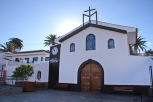
Church of Our Lady of Guadalupe
The parish church of Our Lady of Guadalupe is a capacious building with the image of the name giving saint inside, work of the sculptor Ezequiel de León y Domínguez, carried out in the 1980’s.
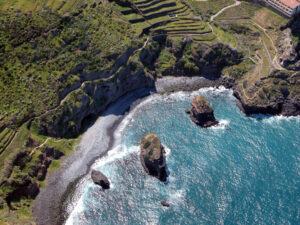
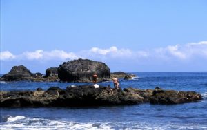
“El Burgado” Cove
Burgado is a kind of sea snail – phorcus atratus – from the family of the top snails. “Caleta del Burgado” is the old name for the “Los Roques” beach, that derives its name from the three rock formations that exist there. These are called “Roque Chico” (small rock), “Roque Grande” (big rock) and “La Pata” (the paw).
Popular Place Names
All along the coast, fishermen gave the beaches, ponds and davits interesting and picturesque names, such as “Callao de Méndez” (callao = pebble beach), “Pejereyes” (sardines) or “Piedra Cagalamagua”.
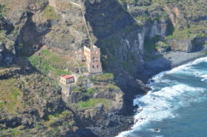
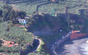
Gordejuela Pumping Station
The Gordejuela pumping station was planned by the house of Hamilton and the project was commissioned to the engineer José Galván Balaguer. Construction started in November of 1903 and ended in June of 1907. The boilers were set up at 100 metres distance from the building with a 43 metre high tower and plumbing and steam engines which were the first ones on the island of Tenerife.
Godínez Ravine
Godínez is only one of the names given to this ravine along its course. It is the result of several tributaries that join, starting in the mountains, down to the sea, receiving the names of “La Calera”, “La Lora”, “Godínez”, “La Fajana” or “del Agua”.
The Monster of San Vicente
In 1970 strange noises were heard coming from a cave in the area, but it was never found out what caused them, although several stories existed to this effect. The episode, reported in all the local papers, became known as the “Monster of San Vicente”.
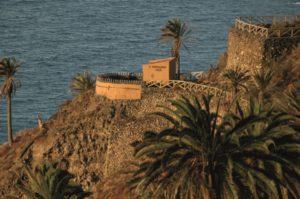
San Fernando's fortress
The fortress of San Fernando is one of three coastal batteries that existed in the old municipality of Realejo Bajo. It was built in 1808 to protect the locals from pirate attacks.
Castro dragon tree
The Castro dragon tree (Dracaena draco) is a magnificent specimen that stands out in the lush palm grove. Observing its trunk and its branches, we can estimate it to be around 150 years old.

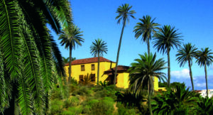
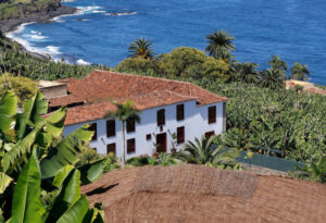
Castro Manor
The Castro or “Mayorazgo” estate is the principal and oldest estate on the coast. It offers retreats of suggestive beauty where the sound of the sea is sometimes drowned out by birdsong. Originally built in the 16th century by Hernando de Castro, the current building stems from the 17th and 18th centuries with parts added later on. It was surrounded by spacious gardens that went to the rim of the lush ravine in front of Castro or “camel”
beach.
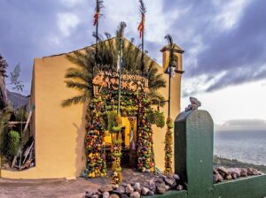
Saint Peter's hermitage
The hermitage of Saint Peter must have been built during the first years of the 17th century. Situated beneath the outlook of the same name, from its entrance you get an unsurpassable view over the entire nature reserve. Every 29th of June a beautiful arch of fruit and vegetables is displayed on the outside to commemorate the saint.
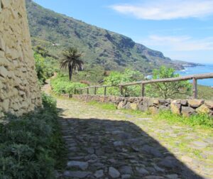
Caminos reales
Centuries ago the roads connecting our villages were called “caminos reales”. The camino real passes by Saint Peter’s hermitage and is one of the few sections preserved in the municipality of Los Realejos.
El Guindaste
The place name “El Guindaste” (jib crane) derives from its past as a pier. It denominates a structure consisting of three beams that was used to load and unload boats.
The “Cuatro Ventanas” Estate
The house “Las Cuatro Ventanas” (four windows) which today is a tourist accommodation, belonged to the Vergara and del Hoyo families and later to the marquisate of Celada. Its name derives from the windows in its upper floor that overlook the sea.

The Estate of the Viscount of Buen Paso
Along the old “Camino de los Morales” (Bramble Road) which is still called by its old name even though nowadays no brambles exist in the area any more, stands the Hacienda which elonged to the viscount of Buen Paso and marquis of San Andrés. It had dwellings for the sharecroppers, gardens, seating areas and the main house with a U-shaped floor plan, inside which is a courtyard which was divided by a wall after the partition was made in 1863.
The Socorro Estate
In the area of “Babón” lies the estate “Hacienda del Socorro” which is named after the hermitage built to Our Lady of Perpetual Help around 1617. Inside, the full-size statue of the name-giving saint presides over an interesting altarpiece in which the portraits of the founding family appear.
Flora y fauna
If we pay a little attention along the way, we can observe the most representative passerines of the coastal areas of the island’s north, between Los Roques beach and the San Pedro lookout. Among the species and subspecies we can see here are the Eurasian blue tit and the leaf warbler, the Eurasian blackcap and the Sardinian warbler, blackbird, grey wagtail and the ever present Atlantic canary. Some of these small birds, but especially the leaf warblers and the Sardinian warblers, like to build their nests in the dense Canary incense that grows close to the house.
In the surroundings of the Rambla de Castro estate manor we find a large, apparently man made grove of Canary palm trees (Phoenix canariensis). In places the foliage creates a dense cover where leaves and trunks intertwine, forming a refuge for winged species such as the long-eared owl or certain types of bats.
From a geological point of view, and even delving into paleontology, a journey through this part of the island’s north coast offers insights into relevant and little known facts. With help of a specialist guide we can discover elevated beaches, the remains of large scale landslides,
the imprints of plants in rocky layers and molds of thermophile trees and bushes that were covered by ancient streams of lava.
Route Description
 We start from the Church of Our Lady of Guadalupe en descend along the main road, passing through the Toscal-Longuera shopping area where we find shops and businesses. The parish church of Our Lady of Guadalupe was built by initiative of the parish priest
Antonio María Hernández who was supported by the locals of the growing town centre of Toscal Longuera. It is a spacious building featuring the name giving saint which was made by the sculptor Ezequiel de León y Domínguez in the 80’s of the past century.The Toscal Longuera town centre emerges in the 20th century due to the large plantations of the area, especially those of the Gorvorana estate. Many houses for workers and day labourers were built along the road that went to Puerto de la Cruz. There are two distinct areas: La Longuera in the higher part and El Toscal in the lower. Urban development spurs the construction of the urbanisations of Los Potreros and Los Bancales as new areas for private construction and housing promotion in what is now one of the most densely populated areas of Los Realejos. The terms “Longuera” and “Toscal” refer to types of terrain. Longuera denominates long, narrow terrains, whereas Toscal refers to a type of soil.
We start from the Church of Our Lady of Guadalupe en descend along the main road, passing through the Toscal-Longuera shopping area where we find shops and businesses. The parish church of Our Lady of Guadalupe was built by initiative of the parish priest
Antonio María Hernández who was supported by the locals of the growing town centre of Toscal Longuera. It is a spacious building featuring the name giving saint which was made by the sculptor Ezequiel de León y Domínguez in the 80’s of the past century.The Toscal Longuera town centre emerges in the 20th century due to the large plantations of the area, especially those of the Gorvorana estate. Many houses for workers and day labourers were built along the road that went to Puerto de la Cruz. There are two distinct areas: La Longuera in the higher part and El Toscal in the lower. Urban development spurs the construction of the urbanisations of Los Potreros and Los Bancales as new areas for private construction and housing promotion in what is now one of the most densely populated areas of Los Realejos. The terms “Longuera” and “Toscal” refer to types of terrain. Longuera denominates long, narrow terrains, whereas Toscal refers to a type of soil.- Leaving the main road we turn left onto the street “calle Media Cuesta”. We descend along “calle El Cardón” to the intersection with the street “calle El Cedro”. Our walk through the sopping area of Toscal-Longuera takes us to the Cross Chapel of El Toscal, the religious reference point of that geographical area. The cross was installed there decades ago by the locals, next to the road and as a measure of spiritual protection for those who traveled through there. This cross is one of the many on the list of crosses of Los Realejos which is celebrated every year during the May festival of crosses and fire, which was the first festival to be declared of touristic interest in the Canaries. An the end of the street “calle El Cardón” and turning a few meters left into the “calle El Cedro” we can see from above the so called “Burgado” (top snail) cove, also called “Los Roques” beach. In this area, at the foot of a Canary Island date palm we can also find a water reservoir with its corresponding water management infrastructures.
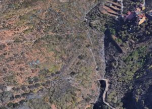
- We link up with a dirt track that takes us to a cemented path that runs between the fence of a banana plantation to the left and a concrete wall on the right. From here we can see the volcanic cones of “Montaña de la Horca” and “Montaña de Los Frailes”. According to the locals, this section belongs to a road called “camino Los Beltranes” which went through part of the lower portion of the neighbourhood and connected to the road “camino El Burgado”, as we shall see further on. This land, formerly dedicated to the cultivation of wine, currently grows one of the seven varieties of bananas that are cultivated on the islands. Depending on the time of year we pass by, we can observe the different stages of growth, bloom and production.
- After getting to a dirt track we reach a section of stone paved path with a bit of a slope and curves through abandoned terraces, very close to the residential area of the Acapulco and Maritim apartments. A short section of this interesting paved trail remains which looks like it could have been an old “Camino Real” with appropriate width and shoulder construction. Without bein able to say so for certain, it could be part of the road known as “El Burgado” that connected Los Realejos and Puerto de la Cruz and led past the Gorvorana estate. Other interesting elements are preserved along this road, such as reservoirs, basins and small tanks that speak of a productive and generous agricultural past. In this area we can see vegetable gardens on terraces, now abandoned, old stone constructions with monk and nun style roofs next to new hotels, sports and leisure facilities.
- We enter the road of “Playa de Los Roques” and turn left. We see a sign that warns of possible rockfall on this section and we pass to our right hand the path that goes down to the beach. We reach an intersection that to the right leads to the residential and hotel area, and to the left takes us down the proposed trail.On this section we can appreciate the beauty of Burgado cove or Los Roques beach, as it is also known. We have views to the “Roque Chico”, “Roque Grande” and “La Pata” rock formations which receive their names from their shapes and collective imagination. On the large rock – “Roque Grande” – existed a large population of Canary Island spurges which have all but disappeared nowadays, due to a number of causes such as nitrification of the soil and the excrement of the rather large population of rock doves. We know of interesting graphical documents, etchings as well as photographs, which depict boats at this idyllic place, possibly an anchorage close to port. Many of the plant species of this route can be observed here, among them: palm trees, dragon trees, olives and juniper, all of which are typical for the Mesocanarian level of vegetation or thermophilic forest. Also, tall-growing shrubs, such as: Canary Island spurge, balsam spurge, periploca, rubia fructosa, morning-glory-tree, danewort, Moquin’s marcetella, rumex lunaria, echium, kleinia neriifolia, and others of shorter growth, like dogfennel, frankenia, Canary dandelion, tree housleek, Canary lavender and pericallis. “Los Roques” beach is made up of pebbles and black sand and is popular with the locals. The best time to visit here is September because then the beach is completely covered in sand. We nevertheless have to warn of the danger from the sea currents that are present there. On the cliff we can see an old water canal: the “Aguas del Rey” canal. It was used to collect water that emerged from various points of the cliff and to conduct it down to Puerto de la Cruz.
- Continuing along the path and passing to the right hand the trail that leads to the outlook of “La Poyata”, we continue up the cobbled section above “Los Roques” beach. In this area, also made up of old, abandoned terraces, we find interesting vegetation, especially Canary Island spurge and balsam spurge, without forgetting the fauna that inhabits this space. If we approach the viewpoint of La Poyata we can enjoy the panorama over the beach and also contemplate part of the north coast of the island, especially nearby Puerto de la Cruz.
- The route now takes us to the streets of the urbanization of “La Romántica II” where to the right we have the streets called “calle Amapolas” and “calle Las Palmeras” and lastly “calle Los Geranios” where we turn right. We walk through this urbanisation which was built in the seventies of the past century, to expand of the tourist capacity of the municipality of Los Realejos and as an alternative for tourists that went to Puerto de la Cruz. Although we do not get to go there, it is interesting to know that a night club existed nearby called “Cueva Romántica” which was closed a long time ago, but well known and visited in its years of operation. It was built at the same time as the urbanization, taking advantage of an existing cave in the cliffs. Tourists from all over the island used to come here to enjoy the shows that were performed here. The gardens and recreational areas have been populated by numerous species that combine with the native flora. Thus we find washingtonia palms, araucarias, yuccas, bougainvillea and many varieties of ornamental flowers.
- Reaching the intersection with “calle Los Geranios” we turn right onto the trail above the “Riscos de Mñendez” cliffs. The trail is initially flanked by tamarisks and bands of rough rock. We take the road along the lands known as Mendez’s. The name derives from the colonizer Juan Méndez who obtained a series of strips of land in this part of the island. Cultivated until a few decades ago, they are currently abandoned. The place name “Callao de Méndez” (Mendez’s shingle beach) and other names relating to rocks and places that fishermen know well, still remain, as they enter this area all year round to reach their favourite fishing grounds, which often has them crossing dangerous trails. We will also see some well preserved Canary Island spurges and other species of this coastal ecosystem accustomed to living on the steep cliffs.
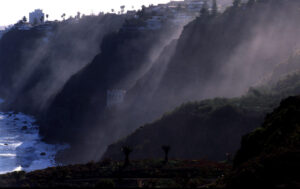
- We can stop at various turns of the road to contemplate the views of the coast that we have from these points. We can see all the way from the north-west coast, called “Isla Baja” to the shallows of El Pris in Tacoronte in the north-east. At certain, more salient areas the winding road takes us to outlooks where we can appreciate the beauty of the landscape that the north coast of the island of Tenerife offers with its steep cliffs, escarpments and dried watercourses.
- Before we reach the wooden bridge of the Gordejuela or Palo Blanco ravine, we find an optional exit that leads to calle Buganvilla and to the Romantica I urbanisation to the left. After crossing the bridge we climb up a stone paved slope ro the La Merina road and a cement trail that takes us to the Gordejuela rural house, leaving the road down to the semiderelict Gordejuela pump-station to the right. We reach the edge of the Gordejuela ravine, where we can see part of the coast of the Rambla de Castro. From here we have an excellent view of the Gordejuela pump-station. The presence of water in the area and the need to collect it was what led to the construction of the pump-station. From above the ruins of the station, the visitor can appreciate the impressive architecture of the abandoned building. It was built by the engineer José Galván Balaguer by commission of the house of Hamilton. The boilers were placed 100 meters from the building with a tower 43 meters high, as well as pipes and steam engines that were the first on the island of Tenerife. Construction began in November 1903 and ended in June 1907.
- Leaving La Gordejuela Rural House behind us, the road of La Merina leads us to a crossroads where we turn to the right, entering the Siete Fuentes estate to explore the cliffs of the coast of La Fajana. If we continue up the “camino de La Merina” we can reach Las Toscas de San Agustín and Puerto Franco street. On the way we pass old farmland, some of it within the estates of the aforementioned Juan de Gordejuela and know as the Patronage, due to his foundation for the maintenance of the convents he established in the municipality. Much of it is currently abandoned but in the past it was used to cultivate ornamental plants and flowers. To the left, at the beginning of our descent, we can see a number of caves with walls of rough stone that were used as temporary housing and storage for crops and farm utensils of the surrounding farms.
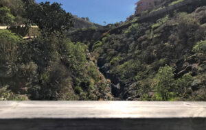
- We descend into the Godinez ravine, passing over a small bridge that allows us to stand right above the centre of the ravine’s bed. From here we go into the Rambla de Castro. Godínez is just one of the names that the ravine receives along its route. It is the result of several tributaries that come together from the summits down to the sea and go by the names of “La Calera”, “La Lora”, “Godínez”, “La Fajana”, “del Agua”. In the past it was also known as “de Agustín de León” and “Barranco Hondo del Señor San Sebastián”. We can appreciate its depth and the amount of water that flows down it in rainy times by observing the erosion of the bed’s stony ground. At the beginning of the seventies of the 20th century, a series of paranormal events took place in this ravine, that were reported by the press throughout Spain. Strange noises emanated from a cave whose origin, however, was never determined, because there were a number of different versions about them. Hundreds of curious people visited the place for several months to find out what was going on. The phenomenon is known as the “Monster of San Vicente”.
- We continue along the main trail and pass the descent to La Fajana beach to the right. The place name “La Fajana” which can also be found in other parts of the municipality and on the Canary Islands in general, refers to flat areas that formed at the foot of slopes and escarpments, from sediment of those hillsides.
- From the left arrives the track that comes from the large Indian laurel located on the main trail and we go to the palm grove of the Rambla de Castro, past a new road that appears on our left. Continuing along the main path we get to locate ourselves above the San Fernando’s fort. From this projected position we can contemplate the beach of Castro on one side and the beach of La Fajana on the other, with the ruins of the Gordejuela pump-station in the background.
- From here we can descend to the San Fernando’s fort outlook. This fort is one of three coastal batteries that existed along the coast of the of municipality of Realejo Bajo. It was built in 1808 to protect the population from pirate attacks. Of the original five cannons, three still remain intact. In this area we walk among balsam spurge, morning-glory-trees, clary sage, a few junipers and re-planted wild olives.
- Continuing on our way we pass three intersections that take us to the entrance to the fort and toward the old trail that takes us to the dragon tree of the Rambla de Castro and the palm grove. We can appreciate the natural richness of the place, especially in this area where the largest number of palm trees is concentrated, most of them centenarians. The dragon tree (dracaena draco) could be about 150 years old, looking at its branching an the appearance of its trunk. It is possibly one of the few surviving in this place, since we are in an area well suited for its proliferation, and this one being one of those in Los Realejos which is situated closest to the sea.
- Following the main trail, we pass on the right the path that goes down to the beach of Castro and also leads to the fort, and a few meters further on, on the left, we find one of the intersections that leads to the spring “Madre del Agua” (“mother of water” in English). Several travelers spent some time at the Castro estate manor, thanks to the generosity of the Bethencourt y Castro family, who inherited the old estate. Among them Sabino Berthelot or Jean Mascart who offered literary descriptions of the area. Between 1820 and 1830 Sabino Berthelot said: “After a short distance you get to the Rambla de Castro where you meet a different landscape. The work of man has complemented nature and converted this beautiful place into a pleasant residential space. Then, leaving these groves and the evocative labyrinth to the right, the scenery changes again, ahead there is only a stony beach; behind of which a wall of basalt towers over it as if it wanted to bury the beach under her powerful mass.” Jean Mascart in 1910 wrote the following: “Soon we arrived at the Rambla de Castro, the best known of these ravines and one of the deepest. It never lacks water and the vegetation is splendid. It forms a corridor between walls covered with ferns and mosses, with trickles of limpid water, a series of terraces and small bridges to cross from one to the other. It is a ravine in Eden. Along fallen trunks and flowers, butterflies and insects swarm among the babbling waterfalls. Below, there are banana plantations. The light is exquisite and soft, sifted, between the hot sun and the ocean that resounds with violence at our feet. Once again we have to separate ourselves from this unforgettable show. Now nature shows itself more beaming than ever.”
- We continue along the main trail and reach the “Hacienda de Castro”. This is an interesting building with various constructions built in various stages over the centuries. It was founded by Hernando de Castro, “El Viejo” (the Elder) on land obtained after the conquest of the island had finished. Years later, the Majorat is founded and the hereditary line begins, with the brothers José and Agustín Bethencourt y Castro operating the estate during the 19th century. The house, built around a central courtyard is up to three stories high on some sides, making for a large, capacious building. Remarkable items of this construction are the wall with battlements, the basins for laundry, benches, settees and some old winepress-stones that belonged to presses that no longer exists today.
- From the house we go upwards along the cobbled trail and turn right, leaving the main path to enter a stretch with palm trees. If we continue along the cobbled trail, to the left we will find the entrance to the “Mother of Water”, a spring that still emanates water which his collected in a reservoir for later usage. Inside the ravine, where the caves are from which the water comes, we can find a specimens of willows and other plants that thrive in humid environments. Further along the stone paved trail is a large Indian laurel which was possibly planted there in the 19th century, when the area had gardens and paths and resting places were created, and plants from other parts of the world were introduced. Very close to this place is a cave – now walled – that is said to have once been inhabited by natives. As far as animal life is concerned, in this specific area we can encounter birds such as leaf warblers, blackcaps and Sardinian warblers, common blackbirds, gray wagtails, common canaries and Eurasian blue tits, as well as nocturnal birds, like owls.
- After walking across a short, wooden gangway we reach the old Mayorazgo road and ascend to the left. To the right is a path that goes to the natural pools of “El Guindaste”. The Mayorazgo road leads us past orchards and simple buildings until it gets to the sugar mill’s goods station and the cape of “El Guindaste”. Here the production of the sugar mill from “El Adelantamiento” and “Castro” as well as the produce from the surrounding farms were loaded onto ships. The name “guindaste” denominates a construction made of three poles and a rope which was used to load and unload the boats (a type of jib crane). There used to be another coastal defense fortress with canons in this area. Today it is visited by many bathers, fishermen and diving enthusiasts because from here you reach the shoal of Realejos with its enchanting submarine landscape.
- Leaving the descent to “El Guindaste” behind us and after an ascending section, to the right we get onto stretch of even, paved road which we follow passing the continuation of the ascent that takes us to the San Pedro’s hermitage and the homonymous lookout. We walk on the old “Camino Real” along the coast which used to be the road that connected all the villages in the north of Tenerife. Its original cobble stones are still intact thanks to work sponsored by the Island’s government. One of the best preserved stretches is this one in Los Realejos.The Saint Peter hermitage must stem from the first years of the 17th century. Before then, another hermitage to Saint Peter existed in the “barranco de Ruiz” ravine, but that was destroyed during a flood. Construction is due to the owner of the Majorat, Pedro de Castro Navarro, who – according to documents – built it opposite the cross of Castro. The image of the saint that was made in Andalusian workshops, has the iconographic features conforming to an apostle. Every 29th of June a liturgical commemoration for the saint takes place where a beautiful arch is decorated with fruit and vegetables outside the hermitage.
- We leave the cobbled road and walk along a paved street to the left, past the road that descends to the “Las Chozas” estate, cape “El Guindaste” and the urbanisation of “Ramblas del Mar”. The “Las Chozas” hacienda is an interesting building with a wide wooden gallery and roof tiles, open to the old road of “El Guindaste”, nowadays called “Ramblas del Mar”. It is known to have belonged to the majorat founded by Luís Benítez del Hoyo in 1598. In those days it consisted of several houses, winery and a water reservoir. It extended from the cliffs down to the ocean. The place known as “Punta del Guindaste” was sold in the mid-20th century to construct houses in the area of “Ramblas del Mar”. Since then it has become one of the most sought after areas in the north of Tenerife. Constructed with simple, two-story houses it sits above the natural pools of “El Guindaste”, in a privileged location due to its climate.
- At the next crossroads we continue, following the road to the right, passing between the “Hacienda de las Cuatro Ventanas” estate on the left and the road that leads to the “Hacienda de La Rambla” on the right, between banana plantations.The house “Las Cuatro Ventanas” belonged to the families of Vergara and del Hoyo and later became property of the marquis of Celada. An ample complex made of two buildings with the windows facing north and a series of annexes on the south side. Nowadays it serves as tourist accommodation. The estate known as “La Rambla” is made up of a group of simple buildings used as homes for owners and leaseholders. In the past it had a winery and cellars as well as a porch and an ample courtyard. Banana farming has influenced the use of the land as well as the shape of the infrastructure. An interesting specimen of dragon tree exists in this area: the dragon tree of “Rambla del Mar” with a slender canopy that extends over a sea of banana plantations.
- Very nearby we can find the road of “Los Morales” to the left that comes from Tigaiga and that leads us to the hacienda of the viscount of Buen Paso. Next to the “Los Morales” (blackberry) road, which conserves its name although no blackberries exist in the area any more, stands the estate that belonged to the viscount of Buen Paso and the marquis of San Andrés. It used to have housing for the leaseholders, a garden and the main house with a U-shaped floor plan and a courtyard that is divided by a wall after the property was sectioned in 1863.
- We continue along the road to Socorro beach, between banana plantations, passing the farms of Babón and El Socorro on our left, where the main house and the hermitage of Our Lady of Perpetual Help is located. Bananas have been farmed there since the 19th century, thanks to the commercial estates that started exporting them to the European markets, especially to England. Despite the passage of time and the abandonment of some of the productive lands, the farms of La Rambla continue to be a reference for banana cultivation on the island of Tenerife. In the Babón area stands the hacienda “El Socorro” which derives its name from the hermitage built in honour to Our Lady of Perpetual Help around 1617. Inside stands a full sized statue in front of an altarpiece with the portraits of the founding family.
- We reach the Socorro beach with its black sand that is popular because of its clean water and to practice water sports such as bodyboarding and surfing . At this final point in the itinerary the hiker can go for a refreshing swim in the clear waters of the beach, rest, have a snack at the Kiosko Doña Carmen or a meal in the restaurant at the beginning of the promenade. The Socorro beach is named after the nearby estate and hermitage. This area used to be a lush retreat for the locals until the track and later the road were built in the second half of the 20th century which is when this place gained popularity. Years later it became one of the most important areas on the island for surfers. It has received the European blue flag for the past two years running due to the quality of its water, the cleanliness of the area and the services it offers. There is mostly shrubbery in this area, typical of the coast zone, among which we find the following species: tamarisk, sea lettuce, frankenia, dogfennel, eternal flower, rumex lunaria and Canary dandelion.
Data sheetTransportRecommendations
Details
| Difficulty | Fácil |
| Duration | 2:00 horas |
| Circular | No |
| Distance | 5,70 km |
| Going up | 3,02 km (53%) |
| Going down | 2,67 km (47%) |
| Max. height | 170,77 mts |
| Min. height | 22,73 mts |
| Slope | 148,04 mts |
| Acc. drop | 495,00 mts |
BUS (http://www.titsa.com):
- Toscal (Código 4165): Lines 381, 354, 353
- Hotel Maritim (Código 4931): Line 381
- Mirador de San Pedro (Código 4330): Lines 363, 108, 546
- El Socorro junto a TF5 (Código 4331): Lines 107, 108, 363, 325
- Playa del Socorro (Código 5067): Line 546. Solo funciona en Verano
- Servitaxi Realejos: 922 346 045
- Radio Taxi: 922 346 096
PLAN AHEAD: When organising your hike, don’t forget to bring your charged mobile phone, sun protection cream, hat, adequate clothes and shoes, as well as sufficient water and food.
HIKE IN COMPANY: Before setting out, consult the meteorological conditions to make sure they are adequate. Inform family or friends about your route and only walk on marked paths.
AVOID MAKING NOISE: You will enjoy nature better in silence.
DON’T LEAVE RUBBISH: Take any rubbish with you, including anything organic and be
especially careful with cigarette ends. This way you help maintain the beauty of the landscape and prevent the proliferation of rodents.
RESPECT THE ENVIRONMENT: Don’t pick plants and don’t take animals or objects from
their surroundings. Respect the locals’ way of life.
BE CAREFUL: Hiking in nature holds risks. You hike under your own responsibility.
LEGAL DISCLAIMER
This leaflet is meant to be informative. The information it contains can depart from reality and cannot precisely represent the actual state of trails and paths which may have suffered alterations due to weather and other factors after this information was printed.
We remind you that adequate means and equipment have to be used for hiking and that you should always act with the necessary precaution that this activity demands.
The town hall of Los Realejos publishes this leaflet to make the trails of the municipality known to the public and does in no manner assume responsibility for its incorrect or negligent usage.